|
|
|||||||||||||||||
| Point ID: 7411 | Downloads | Plots | Site Data | Code: 70248 |
|
|
|||||||||||||||||
| Download | |
|---|---|
| Site Descriptor Information | Site Time Series Data |
| Link to all available data | |
| View: | Time Series | All |
| Units: | mm |
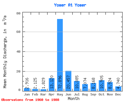
| Statistic | Jan | Feb | Mar | Apr | May | Jun | Jul | Aug | Sep | Oct | Nov | Dec | Annual |
|---|---|---|---|---|---|---|---|---|---|---|---|---|---|
| Mean | 2.92 | 2.12 | 1.83 | 13.12 | 72.90 | 20.46 | 10.09 | 7.07 | 8.17 | 10.90 | 8.92 | 4.74 | 13.63 |
| Standard Deviation | 1.20 | 0.66 | 0.47 | 16.39 | 24.04 | 7.60 | 6.79 | 4.89 | 4.98 | 5.59 | 4.43 | 2.41 | 2.67 |
| Min | 1.39 | 0.97 | 0.83 | 1.65 | 29.50 | 7.14 | 3.47 | 2.43 | 2.59 | 3.82 | 2.90 | 1.62 | 8.21 |
| Max | 7.22 | 4.35 | 3.09 | 71.80 | 116.00 | 39.60 | 37.90 | 24.30 | 21.30 | 31.60 | 20.10 | 13.90 | 19.79 |
| Coefficient of Variation | 0.41 | 0.31 | 0.26 | 1.25 | 0.33 | 0.37 | 0.67 | 0.69 | 0.61 | 0.51 | 0.50 | 0.51 | 0.20 |
 Return to R-Arctic Net Home Page