|
|
|||||||||||||||||
| Point ID: 7411 | Downloads | Plots | Site Data | Code: 70248 |
|
|
|||||||||||||||||
| Download | |
|---|---|
| Site Descriptor Information | Site Time Series Data |
| Link to all available data | |
| View: | Time Series | All |
| Units: | m3/s |
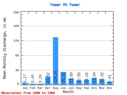
| Statistic | Jan | Feb | Mar | Apr | May | Jun | Jul | Aug | Sep | Oct | Nov | Dec | Annual |
|---|---|---|---|---|---|---|---|---|---|---|---|---|---|
| Mean | 5.17 | 3.43 | 3.24 | 22.52 | 129.28 | 35.12 | 17.89 | 12.55 | 14.02 | 19.34 | 15.32 | 8.41 | 284.80 |
| Standard Deviation | 2.13 | 1.07 | 0.83 | 28.14 | 42.63 | 13.05 | 12.04 | 8.68 | 8.54 | 9.91 | 7.60 | 4.28 | 55.79 |
| Min | 2.46 | 1.57 | 1.47 | 2.83 | 52.32 | 12.26 | 6.15 | 4.31 | 4.45 | 6.78 | 4.98 | 2.87 | 171.70 |
| Max | 12.80 | 7.03 | 5.48 | 123.25 | 205.73 | 67.98 | 67.22 | 43.10 | 36.56 | 56.04 | 34.50 | 24.65 | 413.69 |
| Coefficient of Variation | 0.41 | 0.31 | 0.26 | 1.25 | 0.33 | 0.37 | 0.67 | 0.69 | 0.61 | 0.51 | 0.50 | 0.51 | 0.20 |
 Return to R-Arctic Net Home Page