|
|
|||||||||||||||||
| Point ID: 7406 | Downloads | Plots | Site Data | Code: 70234 |
|
|
|||||||||||||||||
| Download | |
|---|---|
| Site Descriptor Information | Site Time Series Data |
| Link to all available data | |
| View: | Time Series | All |
| Units: | mm |
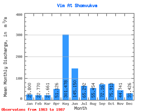
| Statistic | Jan | Feb | Mar | Apr | May | Jun | Jul | Aug | Sep | Oct | Nov | Dec | Annual |
|---|---|---|---|---|---|---|---|---|---|---|---|---|---|
| Mean | 25.80 | 22.77 | 21.66 | 51.13 | 301.48 | 145.15 | 65.29 | 55.45 | 72.17 | 75.91 | 44.74 | 31.43 | 76.78 |
| Standard Deviation | 2.50 | 2.15 | 1.98 | 63.76 | 83.46 | 81.98 | 25.16 | 21.24 | 26.82 | 28.58 | 15.47 | 5.59 | 10.68 |
| Min | 22.80 | 18.80 | 18.10 | 17.20 | 193.00 | 54.60 | 35.70 | 34.80 | 36.10 | 44.80 | 27.50 | 22.80 | 59.76 |
| Max | 30.70 | 27.30 | 24.30 | 291.00 | 556.00 | 420.00 | 147.00 | 113.00 | 117.00 | 154.00 | 91.30 | 47.50 | 109.66 |
| Coefficient of Variation | 0.10 | 0.10 | 0.09 | 1.25 | 0.28 | 0.56 | 0.39 | 0.38 | 0.37 | 0.38 | 0.35 | 0.18 | 0.14 |
 Return to R-Arctic Net Home Page