|
|
|||||||||||||||||
| Point ID: 7406 | Downloads | Plots | Site Data | Code: 70234 |
|
|
|||||||||||||||||
| Download | |
|---|---|
| Site Descriptor Information | Site Time Series Data |
| Link to all available data | |
| View: | Time Series | All |
| Units: | m3/s |
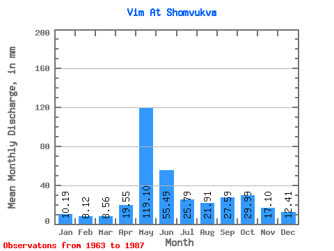
| Statistic | Jan | Feb | Mar | Apr | May | Jun | Jul | Aug | Sep | Oct | Nov | Dec | Annual |
|---|---|---|---|---|---|---|---|---|---|---|---|---|---|
| Mean | 10.19 | 8.19 | 8.56 | 19.55 | 119.08 | 55.49 | 25.79 | 21.90 | 27.59 | 29.98 | 17.10 | 12.41 | 357.39 |
| Standard Deviation | 0.99 | 0.78 | 0.78 | 24.38 | 32.97 | 31.34 | 9.94 | 8.39 | 10.25 | 11.29 | 5.92 | 2.21 | 49.73 |
| Min | 9.01 | 6.77 | 7.15 | 6.58 | 76.23 | 20.87 | 14.10 | 13.74 | 13.80 | 17.70 | 10.51 | 9.01 | 278.17 |
| Max | 12.13 | 9.82 | 9.60 | 111.25 | 219.61 | 160.57 | 58.06 | 44.63 | 44.73 | 60.83 | 34.90 | 18.76 | 510.44 |
| Coefficient of Variation | 0.10 | 0.10 | 0.09 | 1.25 | 0.28 | 0.56 | 0.39 | 0.38 | 0.37 | 0.38 | 0.35 | 0.18 | 0.14 |
 Return to R-Arctic Net Home Page