|
|
|||||||||||||||||
| Point ID: 7385 | Downloads | Plots | Site Data | Code: 70176 |
|
|
|||||||||||||||||
| Download | |
|---|---|
| Site Descriptor Information | Site Time Series Data |
| Link to all available data | |
| View: | Time Series | All |
| Units: | mm |
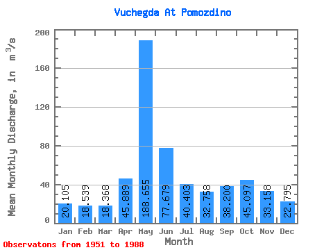
| Statistic | Jan | Feb | Mar | Apr | May | Jun | Jul | Aug | Sep | Oct | Nov | Dec | Annual |
|---|---|---|---|---|---|---|---|---|---|---|---|---|---|
| Mean | 20.11 | 18.54 | 18.37 | 45.89 | 188.66 | 77.68 | 40.40 | 32.76 | 38.20 | 45.10 | 33.16 | 22.80 | 48.47 |
| Standard Deviation | 2.96 | 2.43 | 2.12 | 37.78 | 59.75 | 35.05 | 18.97 | 17.23 | 18.17 | 20.43 | 11.90 | 4.95 | 7.67 |
| Min | 12.70 | 13.10 | 13.90 | 16.90 | 20.60 | 27.40 | 18.80 | 16.90 | 19.00 | 27.80 | 14.80 | 15.20 | 36.36 |
| Max | 25.70 | 23.80 | 22.90 | 162.00 | 318.00 | 189.00 | 98.60 | 92.30 | 97.10 | 142.00 | 61.20 | 37.60 | 68.57 |
| Coefficient of Variation | 0.15 | 0.13 | 0.12 | 0.82 | 0.32 | 0.45 | 0.47 | 0.53 | 0.48 | 0.45 | 0.36 | 0.22 | 0.16 |
 Return to R-Arctic Net Home Page