|
|
|||||||||||||||||
| Point ID: 7385 | Downloads | Plots | Site Data | Code: 70176 |
|
|
|||||||||||||||||
| Download | |
|---|---|
| Site Descriptor Information | Site Time Series Data |
| Link to all available data | |
| View: | Time Series | All |
| Units: | m3/s |
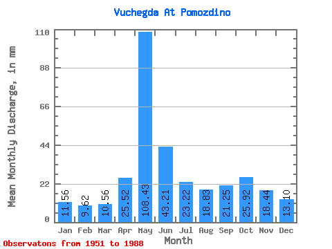
| Statistic | Jan | Feb | Mar | Apr | May | Jun | Jul | Aug | Sep | Oct | Nov | Dec | Annual |
|---|---|---|---|---|---|---|---|---|---|---|---|---|---|
| Mean | 11.55 | 9.71 | 10.56 | 25.52 | 108.42 | 43.21 | 23.22 | 18.82 | 21.25 | 25.92 | 18.44 | 13.10 | 328.27 |
| Standard Deviation | 1.70 | 1.27 | 1.22 | 21.01 | 34.34 | 19.50 | 10.90 | 9.90 | 10.11 | 11.74 | 6.62 | 2.85 | 51.96 |
| Min | 7.30 | 6.86 | 7.99 | 9.40 | 11.84 | 15.24 | 10.80 | 9.71 | 10.57 | 15.98 | 8.23 | 8.73 | 246.24 |
| Max | 14.77 | 12.46 | 13.16 | 90.11 | 182.75 | 105.13 | 56.66 | 53.04 | 54.01 | 81.60 | 34.04 | 21.61 | 464.37 |
| Coefficient of Variation | 0.15 | 0.13 | 0.12 | 0.82 | 0.32 | 0.45 | 0.47 | 0.53 | 0.48 | 0.45 | 0.36 | 0.22 | 0.16 |
 Return to R-Arctic Net Home Page