|
|
|||||||||||||||||
| Point ID: 7384 | Downloads | Plots | Site Data | Code: 70175 |
|
|
|||||||||||||||||
| Download | |
|---|---|
| Site Descriptor Information | Site Time Series Data |
| Link to all available data | |
| View: | Time Series | All |
| Units: | mm |
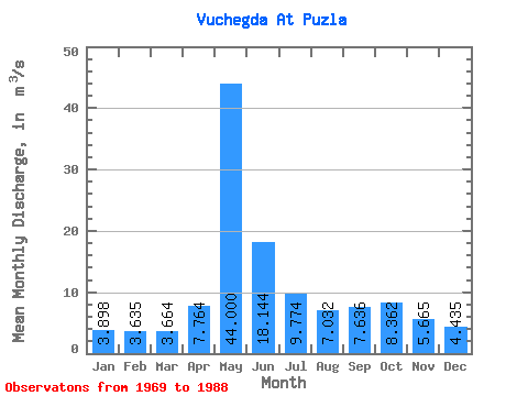
| Statistic | Jan | Feb | Mar | Apr | May | Jun | Jul | Aug | Sep | Oct | Nov | Dec | Annual |
|---|---|---|---|---|---|---|---|---|---|---|---|---|---|
| Mean | 3.90 | 3.63 | 3.66 | 7.76 | 44.00 | 18.14 | 9.77 | 7.03 | 7.64 | 8.36 | 5.67 | 4.43 | 10.38 |
| Standard Deviation | 0.40 | 0.31 | 0.33 | 7.79 | 11.49 | 9.57 | 4.97 | 4.09 | 2.66 | 2.89 | 1.69 | 0.84 | 1.70 |
| Min | 3.33 | 3.10 | 3.09 | 2.87 | 26.80 | 5.60 | 4.57 | 3.82 | 4.24 | 4.92 | 3.50 | 3.24 | 7.27 |
| Max | 4.98 | 4.26 | 4.22 | 34.50 | 70.90 | 42.00 | 21.60 | 22.30 | 13.30 | 14.70 | 9.39 | 6.30 | 12.67 |
| Coefficient of Variation | 0.10 | 0.09 | 0.09 | 1.00 | 0.26 | 0.53 | 0.51 | 0.58 | 0.35 | 0.35 | 0.30 | 0.19 | 0.16 |
 Return to R-Arctic Net Home Page