|
|
|||||||||||||||||
| Point ID: 7384 | Downloads | Plots | Site Data | Code: 70175 |
|
|
|||||||||||||||||
| Download | |
|---|---|
| Site Descriptor Information | Site Time Series Data |
| Link to all available data | |
| View: | Time Series | All |
| Units: | m3/s |
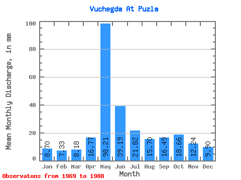
| Statistic | Jan | Feb | Mar | Apr | May | Jun | Jul | Aug | Sep | Oct | Nov | Dec | Annual |
|---|---|---|---|---|---|---|---|---|---|---|---|---|---|
| Mean | 8.70 | 7.39 | 8.18 | 16.77 | 98.19 | 39.19 | 21.81 | 15.69 | 16.49 | 18.66 | 12.24 | 9.90 | 272.85 |
| Standard Deviation | 0.89 | 0.63 | 0.73 | 16.82 | 25.64 | 20.68 | 11.09 | 9.14 | 5.74 | 6.46 | 3.65 | 1.89 | 44.70 |
| Min | 7.43 | 6.30 | 6.90 | 6.20 | 59.81 | 12.10 | 10.20 | 8.53 | 9.16 | 10.98 | 7.56 | 7.23 | 191.18 |
| Max | 11.11 | 8.66 | 9.42 | 74.52 | 158.22 | 90.72 | 48.20 | 49.77 | 28.73 | 32.80 | 20.28 | 14.06 | 333.33 |
| Coefficient of Variation | 0.10 | 0.09 | 0.09 | 1.00 | 0.26 | 0.53 | 0.51 | 0.58 | 0.35 | 0.35 | 0.30 | 0.19 | 0.16 |
 Return to R-Arctic Net Home Page