|
|
|||||||||||||||||
| Point ID: 7376 | Downloads | Plots | Site Data | Code: 70160 |
|
|
|||||||||||||||||
| Download | |
|---|---|
| Site Descriptor Information | Site Time Series Data |
| Link to all available data | |
| View: | Time Series | All |
| Units: | mm |
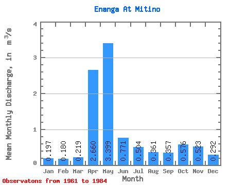
| Statistic | Jan | Feb | Mar | Apr | May | Jun | Jul | Aug | Sep | Oct | Nov | Dec | Annual |
|---|---|---|---|---|---|---|---|---|---|---|---|---|---|
| Mean | 0.20 | 0.18 | 0.22 | 2.66 | 3.40 | 0.77 | 0.50 | 0.36 | 0.36 | 0.58 | 0.52 | 0.29 | 0.84 |
| Standard Deviation | 0.07 | 0.06 | 0.13 | 1.54 | 2.31 | 0.67 | 0.44 | 0.33 | 0.16 | 0.38 | 0.39 | 0.16 | 0.21 |
| Min | 0.08 | 0.08 | 0.11 | 0.57 | 0.50 | 0.18 | 0.13 | 0.15 | 0.17 | 0.21 | 0.20 | 0.08 | 0.48 |
| Max | 0.41 | 0.32 | 0.78 | 6.70 | 8.98 | 3.15 | 1.81 | 1.60 | 0.70 | 1.70 | 1.75 | 0.74 | 1.23 |
| Coefficient of Variation | 0.37 | 0.33 | 0.58 | 0.58 | 0.68 | 0.87 | 0.87 | 0.92 | 0.45 | 0.67 | 0.75 | 0.55 | 0.26 |
 Return to R-Arctic Net Home Page