|
|
|||||||||||||||||
| Point ID: 7376 | Downloads | Plots | Site Data | Code: 70160 |
|
|
|||||||||||||||||
| Download | |
|---|---|
| Site Descriptor Information | Site Time Series Data |
| Link to all available data | |
| View: | Time Series | All |
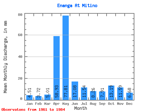
| Units: | m3/s |
| Statistic | Jan | Feb | Mar | Apr | May | Jun | Jul | Aug | Sep | Oct | Nov | Dec | Annual |
|---|---|---|---|---|---|---|---|---|---|---|---|---|---|
| Mean | 4.50 | 3.76 | 5.02 | 58.93 | 77.80 | 17.08 | 11.54 | 8.27 | 7.91 | 13.19 | 11.59 | 6.67 | 225.67 |
| Standard Deviation | 1.69 | 1.25 | 2.92 | 34.13 | 52.89 | 14.81 | 10.02 | 7.61 | 3.59 | 8.78 | 8.69 | 3.70 | 57.74 |
| Min | 1.85 | 1.61 | 2.52 | 12.63 | 11.44 | 3.99 | 2.98 | 3.43 | 3.77 | 4.81 | 4.43 | 1.79 | 128.58 |
| Max | 9.38 | 6.67 | 17.85 | 148.43 | 205.54 | 69.78 | 41.43 | 36.62 | 15.51 | 38.91 | 38.77 | 16.94 | 332.68 |
| Coefficient of Variation | 0.37 | 0.33 | 0.58 | 0.58 | 0.68 | 0.87 | 0.87 | 0.92 | 0.45 | 0.67 | 0.75 | 0.55 | 0.26 |
 Return to R-Arctic Net Home Page