|
|
|||||||||||||||||
| Point ID: 736 | Downloads | Plots | Site Data | Code: 07FD014 |
|
|
|||||||||||||||||
| Download | |
|---|---|
| Site Descriptor Information | Site Time Series Data |
| Link to all available data | |
| View: | Time Series | All |
| Units: | mm |
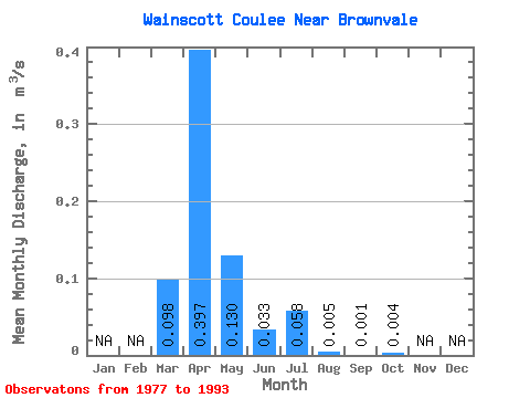
| Statistic | Jan | Feb | Mar | Apr | May | Jun | Jul | Aug | Sep | Oct | Nov | Dec | Annual |
|---|---|---|---|---|---|---|---|---|---|---|---|---|---|
| Mean | 0.10 | 0.40 | 0.13 | 0.03 | 0.06 | 0.01 | 0.00 | 0.00 | |||||
| Standard Deviation | 0.17 | 0.31 | 0.27 | 0.04 | 0.12 | 0.01 | 0.00 | 0.01 | |||||
| Min | 0.00 | 0.01 | 0.00 | 0.00 | 0.00 | 0.00 | 0.00 | 0.00 | |||||
| Max | 0.53 | 0.90 | 1.04 | 0.15 | 0.42 | 0.04 | 0.01 | 0.02 | |||||
| Coefficient of Variation | 1.75 | 0.78 | 2.07 | 1.32 | 2.03 | 2.31 | 2.31 | 2.02 |
 Return to R-Arctic Net Home Page