|
|
|||||||||||||||||
| Point ID: 736 | Downloads | Plots | Site Data | Code: 07FD014 |
|
|
|||||||||||||||||
| Download | |
|---|---|
| Site Descriptor Information | Site Time Series Data |
| Link to all available data | |
| View: | Time Series | All |
| Units: | m3/s |
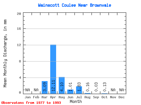
| Statistic | Jan | Feb | Mar | Apr | May | Jun | Jul | Aug | Sep | Oct | Nov | Dec | Annual |
|---|---|---|---|---|---|---|---|---|---|---|---|---|---|
| Mean | 1.77 | 6.90 | 2.33 | 0.58 | 1.04 | 0.08 | 0.02 | 0.07 | |||||
| Standard Deviation | 3.10 | 5.40 | 4.83 | 0.76 | 2.10 | 0.19 | 0.05 | 0.13 | |||||
| Min | 0.00 | 0.16 | 0.00 | 0.00 | 0.00 | 0.00 | 0.00 | 0.00 | |||||
| Max | 9.58 | 15.59 | 18.69 | 2.68 | 7.60 | 0.74 | 0.16 | 0.43 | |||||
| Coefficient of Variation | 1.75 | 0.78 | 2.07 | 1.32 | 2.03 | 2.31 | 2.31 | 2.02 |
 Return to R-Arctic Net Home Page