|
|
|||||||||||||||||
| Point ID: 7356 | Downloads | Plots | Site Data | Code: 70120 |
|
|
|||||||||||||||||
| Download | |
|---|---|
| Site Descriptor Information | Site Time Series Data |
| Link to all available data | |
| View: | Time Series | All |
| Units: | mm |
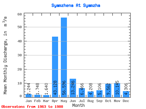
| Statistic | Jan | Feb | Mar | Apr | May | Jun | Jul | Aug | Sep | Oct | Nov | Dec | Annual |
|---|---|---|---|---|---|---|---|---|---|---|---|---|---|
| Mean | 2.24 | 1.75 | 1.64 | 43.13 | 56.60 | 13.25 | 6.47 | 4.21 | 5.11 | 9.56 | 10.14 | 4.31 | 13.25 |
| Standard Deviation | 1.09 | 0.72 | 0.86 | 27.62 | 29.20 | 11.79 | 6.56 | 5.30 | 6.47 | 9.54 | 9.54 | 4.22 | 4.36 |
| Min | 1.00 | 0.83 | 0.60 | 2.91 | 6.71 | 2.12 | 1.33 | 1.00 | 1.23 | 1.47 | 1.13 | 0.86 | 7.39 |
| Max | 4.78 | 3.83 | 4.95 | 112.00 | 119.00 | 41.50 | 29.40 | 26.40 | 26.90 | 39.10 | 36.40 | 16.90 | 23.39 |
| Coefficient of Variation | 0.49 | 0.41 | 0.52 | 0.64 | 0.52 | 0.89 | 1.01 | 1.26 | 1.27 | 1.00 | 0.94 | 0.98 | 0.33 |
 Return to R-Arctic Net Home Page