|
|
|||||||||||||||||
| Point ID: 7356 | Downloads | Plots | Site Data | Code: 70120 |
|
|
|||||||||||||||||
| Download | |
|---|---|
| Site Descriptor Information | Site Time Series Data |
| Link to all available data | |
| View: | Time Series | All |
| Units: | m3/s |
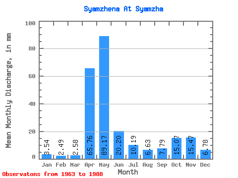
| Statistic | Jan | Feb | Mar | Apr | May | Jun | Jul | Aug | Sep | Oct | Nov | Dec | Annual |
|---|---|---|---|---|---|---|---|---|---|---|---|---|---|
| Mean | 3.53 | 2.51 | 2.58 | 65.76 | 89.16 | 20.20 | 10.19 | 6.63 | 7.79 | 15.06 | 15.47 | 6.78 | 245.91 |
| Standard Deviation | 1.72 | 1.03 | 1.35 | 42.11 | 46.00 | 17.98 | 10.33 | 8.35 | 9.87 | 15.03 | 14.55 | 6.64 | 80.89 |
| Min | 1.57 | 1.19 | 0.94 | 4.44 | 10.57 | 3.23 | 2.10 | 1.57 | 1.88 | 2.32 | 1.72 | 1.35 | 137.21 |
| Max | 7.53 | 5.50 | 7.80 | 170.77 | 187.46 | 63.27 | 46.31 | 41.59 | 41.02 | 61.59 | 55.50 | 26.62 | 434.31 |
| Coefficient of Variation | 0.49 | 0.41 | 0.52 | 0.64 | 0.52 | 0.89 | 1.01 | 1.26 | 1.27 | 1.00 | 0.94 | 0.98 | 0.33 |
 Return to R-Arctic Net Home Page