|
|
|||||||||||||||||
| Point ID: 7354 | Downloads | Plots | Site Data | Code: 70117 |
|
|
|||||||||||||||||
| Download | |
|---|---|
| Site Descriptor Information | Site Time Series Data |
| Link to all available data | |
| View: | Time Series | All |
| Units: | mm |
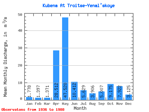
| Statistic | Jan | Feb | Mar | Apr | May | Jun | Jul | Aug | Sep | Oct | Nov | Dec | Annual |
|---|---|---|---|---|---|---|---|---|---|---|---|---|---|
| Mean | 1.78 | 1.40 | 1.37 | 28.51 | 47.52 | 10.41 | 5.63 | 3.91 | 5.01 | 9.18 | 7.92 | 3.12 | 10.49 |
| Standard Deviation | 1.06 | 0.75 | 0.60 | 18.41 | 24.35 | 7.19 | 5.28 | 5.47 | 5.47 | 7.42 | 6.12 | 2.11 | 2.87 |
| Min | 0.69 | 0.47 | 0.48 | 1.50 | 7.43 | 1.56 | 0.70 | 0.57 | 0.52 | 1.06 | 1.05 | 0.88 | 6.17 |
| Max | 6.18 | 4.05 | 2.99 | 77.30 | 119.00 | 33.50 | 22.40 | 34.60 | 22.50 | 31.20 | 24.40 | 11.70 | 17.63 |
| Coefficient of Variation | 0.60 | 0.54 | 0.44 | 0.65 | 0.51 | 0.69 | 0.94 | 1.40 | 1.09 | 0.81 | 0.77 | 0.68 | 0.27 |
 Return to R-Arctic Net Home Page