|
|
|||||||||||||||||
| Point ID: 7354 | Downloads | Plots | Site Data | Code: 70117 |
|
|
|||||||||||||||||
| Download | |
|---|---|
| Site Descriptor Information | Site Time Series Data |
| Link to all available data | |
| View: | Time Series | All |
| Units: | m3/s |
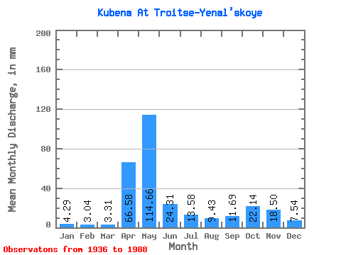
| Statistic | Jan | Feb | Mar | Apr | May | Jun | Jul | Aug | Sep | Oct | Nov | Dec | Annual |
|---|---|---|---|---|---|---|---|---|---|---|---|---|---|
| Mean | 4.29 | 3.07 | 3.31 | 66.58 | 114.65 | 24.31 | 13.58 | 9.42 | 11.69 | 22.14 | 18.50 | 7.54 | 298.30 |
| Standard Deviation | 2.56 | 1.65 | 1.45 | 42.99 | 58.76 | 16.79 | 12.73 | 13.19 | 12.77 | 17.90 | 14.29 | 5.10 | 81.69 |
| Min | 1.67 | 1.03 | 1.16 | 3.50 | 17.93 | 3.64 | 1.69 | 1.38 | 1.21 | 2.56 | 2.45 | 2.12 | 175.47 |
| Max | 14.91 | 8.90 | 7.21 | 180.51 | 287.10 | 78.23 | 54.04 | 83.48 | 52.54 | 75.27 | 56.98 | 28.23 | 501.36 |
| Coefficient of Variation | 0.60 | 0.54 | 0.44 | 0.65 | 0.51 | 0.69 | 0.94 | 1.40 | 1.09 | 0.81 | 0.77 | 0.68 | 0.27 |
 Return to R-Arctic Net Home Page