|
|
|||||||||||||||||
| Point ID: 7339 | Downloads | Plots | Site Data | Code: 70022 |
|
|
|||||||||||||||||
| Download | |
|---|---|
| Site Descriptor Information | Site Time Series Data |
| Link to all available data | |
| View: | Time Series | All |
| Units: | mm |
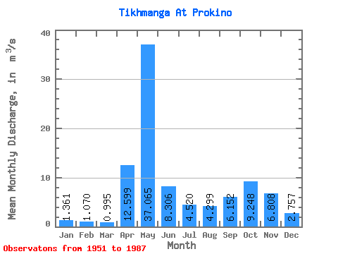
| Statistic | Jan | Feb | Mar | Apr | May | Jun | Jul | Aug | Sep | Oct | Nov | Dec | Annual |
|---|---|---|---|---|---|---|---|---|---|---|---|---|---|
| Mean | 1.36 | 1.07 | 0.99 | 12.60 | 37.06 | 8.31 | 4.52 | 4.30 | 6.15 | 9.25 | 6.81 | 2.76 | 7.94 |
| Standard Deviation | 0.67 | 0.46 | 0.30 | 11.31 | 15.35 | 4.45 | 3.27 | 4.83 | 5.25 | 6.42 | 4.82 | 2.25 | 2.13 |
| Min | 0.62 | 0.59 | 0.60 | 1.33 | 10.60 | 1.92 | 1.05 | 0.61 | 0.58 | 0.74 | 0.71 | 0.62 | 4.18 |
| Max | 3.81 | 2.57 | 1.74 | 41.30 | 76.50 | 22.40 | 14.10 | 20.60 | 19.60 | 23.30 | 20.70 | 13.30 | 11.82 |
| Coefficient of Variation | 0.49 | 0.43 | 0.30 | 0.90 | 0.41 | 0.54 | 0.72 | 1.12 | 0.85 | 0.69 | 0.71 | 0.81 | 0.27 |
 Return to R-Arctic Net Home Page