|
|
|||||||||||||||||
| Point ID: 7339 | Downloads | Plots | Site Data | Code: 70022 |
|
|
|||||||||||||||||
| Download | |
|---|---|
| Site Descriptor Information | Site Time Series Data |
| Link to all available data | |
| View: | Time Series | All |
| Units: | m3/s |
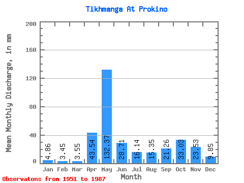
| Statistic | Jan | Feb | Mar | Apr | May | Jun | Jul | Aug | Sep | Oct | Nov | Dec | Annual |
|---|---|---|---|---|---|---|---|---|---|---|---|---|---|
| Mean | 4.86 | 3.48 | 3.55 | 43.54 | 132.35 | 28.70 | 16.14 | 15.35 | 21.26 | 33.02 | 23.53 | 9.85 | 334.23 |
| Standard Deviation | 2.40 | 1.50 | 1.07 | 39.08 | 54.79 | 15.38 | 11.69 | 17.23 | 18.16 | 22.91 | 16.67 | 8.02 | 89.73 |
| Min | 2.21 | 1.92 | 2.14 | 4.60 | 37.85 | 6.64 | 3.75 | 2.18 | 2.00 | 2.64 | 2.45 | 2.21 | 175.89 |
| Max | 13.60 | 8.36 | 6.21 | 142.73 | 273.16 | 77.41 | 50.35 | 73.56 | 67.74 | 83.20 | 71.54 | 47.49 | 497.31 |
| Coefficient of Variation | 0.49 | 0.43 | 0.30 | 0.90 | 0.41 | 0.54 | 0.72 | 1.12 | 0.85 | 0.69 | 0.71 | 0.81 | 0.27 |
 Return to R-Arctic Net Home Page