|
|
|||||||||||||||||
| Point ID: 7337 | Downloads | Plots | Site Data | Code: 70016 |
|
|
|||||||||||||||||
| Download | |
|---|---|
| Site Descriptor Information | Site Time Series Data |
| Link to all available data | |
| View: | Time Series | All |
| Units: | mm |
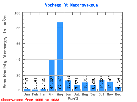
| Statistic | Jan | Feb | Mar | Apr | May | Jun | Jul | Aug | Sep | Oct | Nov | Dec | Annual |
|---|---|---|---|---|---|---|---|---|---|---|---|---|---|
| Mean | 2.71 | 2.14 | 2.48 | 40.03 | 87.03 | 13.47 | 7.57 | 10.92 | 8.21 | 14.02 | 12.07 | 4.75 | 17.28 |
| Standard Deviation | 1.47 | 1.00 | 1.88 | 30.23 | 86.08 | 10.44 | 6.66 | 33.97 | 11.28 | 11.70 | 9.65 | 2.99 | 10.80 |
| Min | 1.33 | 1.09 | 0.95 | 3.56 | 9.45 | 2.80 | 1.10 | 0.53 | 1.23 | 1.72 | 2.16 | 1.59 | 7.90 |
| Max | 8.09 | 5.18 | 9.97 | 107.00 | 474.00 | 47.40 | 23.10 | 198.00 | 60.10 | 48.30 | 38.90 | 14.30 | 67.12 |
| Coefficient of Variation | 0.54 | 0.47 | 0.76 | 0.76 | 0.99 | 0.78 | 0.88 | 3.11 | 1.37 | 0.83 | 0.80 | 0.63 | 0.62 |
 Return to R-Arctic Net Home Page