|
|
|||||||||||||||||
| Point ID: 7337 | Downloads | Plots | Site Data | Code: 70016 |
|
|
|||||||||||||||||
| Download | |
|---|---|
| Site Descriptor Information | Site Time Series Data |
| Link to all available data | |
| View: | Time Series | All |
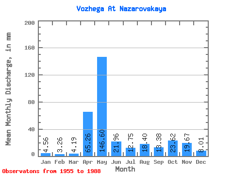
| Units: | m3/s |
| Statistic | Jan | Feb | Mar | Apr | May | Jun | Jul | Aug | Sep | Oct | Nov | Dec | Annual |
|---|---|---|---|---|---|---|---|---|---|---|---|---|---|
| Mean | 4.56 | 3.29 | 4.19 | 65.26 | 146.57 | 21.96 | 12.75 | 18.40 | 13.38 | 23.62 | 19.67 | 8.01 | 343.01 |
| Standard Deviation | 2.48 | 1.54 | 3.17 | 49.28 | 144.99 | 17.01 | 11.22 | 57.22 | 18.38 | 19.71 | 15.74 | 5.03 | 214.32 |
| Min | 2.24 | 1.67 | 1.60 | 5.80 | 15.92 | 4.56 | 1.85 | 0.89 | 2.00 | 2.90 | 3.52 | 2.68 | 156.86 |
| Max | 13.63 | 7.95 | 16.79 | 174.43 | 798.35 | 77.27 | 38.91 | 333.49 | 97.97 | 81.35 | 63.41 | 24.09 | 1332.35 |
| Coefficient of Variation | 0.54 | 0.47 | 0.76 | 0.76 | 0.99 | 0.78 | 0.88 | 3.11 | 1.37 | 0.83 | 0.80 | 0.63 | 0.62 |
 Return to R-Arctic Net Home Page