|
|
|||||||||||||||||
| Point ID: 7327 | Downloads | Plots | Site Data | Code: 49137 |
|
|
|||||||||||||||||
| Download | |
|---|---|
| Site Descriptor Information | Site Time Series Data |
| Link to all available data | |
| View: | Time Series | All |
| Units: | mm |
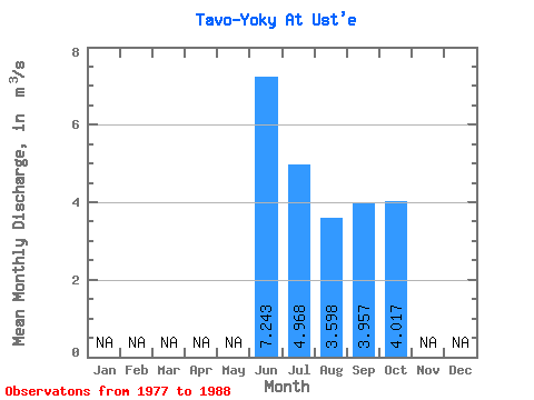
| Statistic | Jan | Feb | Mar | Apr | May | Jun | Jul | Aug | Sep | Oct | Nov | Dec | Annual |
|---|---|---|---|---|---|---|---|---|---|---|---|---|---|
| Mean | 7.24 | 4.97 | 3.60 | 3.96 | 4.02 | ||||||||
| Standard Deviation | 2.22 | 3.22 | 1.75 | 2.08 | 0.96 | ||||||||
| Min | 4.59 | 1.85 | 1.33 | 1.16 | 3.11 | ||||||||
| Max | 9.83 | 14.00 | 7.55 | 8.22 | 5.18 | ||||||||
| Coefficient of Variation | 0.31 | 0.65 | 0.48 | 0.53 | 0.24 |
 Return to R-Arctic Net Home Page