|
|
|||||||||||||||||
| Point ID: 7327 | Downloads | Plots | Site Data | Code: 49137 |
|
|
|||||||||||||||||
| Download | |
|---|---|
| Site Descriptor Information | Site Time Series Data |
| Link to all available data | |
| View: | Time Series | All |
| Units: | m3/s |
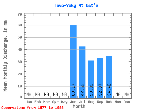
| Statistic | Jan | Feb | Mar | Apr | May | Jun | Jul | Aug | Sep | Oct | Nov | Dec | Annual |
|---|---|---|---|---|---|---|---|---|---|---|---|---|---|
| Mean | 60.17 | 42.64 | 30.89 | 32.87 | 34.48 | ||||||||
| Standard Deviation | 18.41 | 27.62 | 14.99 | 17.30 | 8.25 | ||||||||
| Min | 38.13 | 15.88 | 11.42 | 9.64 | 26.69 | ||||||||
| Max | 81.67 | 120.17 | 64.80 | 68.29 | 44.46 | ||||||||
| Coefficient of Variation | 0.31 | 0.65 | 0.48 | 0.53 | 0.24 |
 Return to R-Arctic Net Home Page