|
|
|||||||||||||||||
| Point ID: 732 | Downloads | Plots | Site Data | Code: 07FD009 |
|
|
|||||||||||||||||
| Download | |
|---|---|
| Site Descriptor Information | Site Time Series Data |
| Link to all available data | |
| View: | Time Series | All |
| Units: | mm |
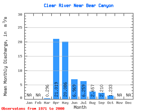
| Statistic | Jan | Feb | Mar | Apr | May | Jun | Jul | Aug | Sep | Oct | Nov | Dec | Annual |
|---|---|---|---|---|---|---|---|---|---|---|---|---|---|
| Mean | 0.30 | 21.02 | 20.09 | 6.97 | 6.26 | 2.66 | 2.21 | 1.23 | |||||
| Standard Deviation | 1.07 | 20.05 | 16.60 | 5.49 | 6.80 | 3.43 | 4.76 | 1.80 | |||||
| Min | 0.00 | 0.91 | 2.55 | 0.94 | 0.25 | 0.02 | 0.02 | 0.07 | |||||
| Max | 5.78 | 85.70 | 66.10 | 21.70 | 26.90 | 16.00 | 25.10 | 9.11 | |||||
| Coefficient of Variation | 3.61 | 0.95 | 0.83 | 0.79 | 1.09 | 1.29 | 2.16 | 1.46 |
 Return to R-Arctic Net Home Page