|
|
|||||||||||||||||
| Point ID: 732 | Downloads | Plots | Site Data | Code: 07FD009 |
|
|
|||||||||||||||||
| Download | |
|---|---|
| Site Descriptor Information | Site Time Series Data |
| Link to all available data | |
| View: | Time Series | All |
| Units: | m3/s |
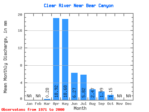
| Statistic | Jan | Feb | Mar | Apr | May | Jun | Jul | Aug | Sep | Oct | Nov | Dec | Annual |
|---|---|---|---|---|---|---|---|---|---|---|---|---|---|
| Mean | 0.28 | 18.92 | 18.68 | 6.27 | 5.82 | 2.47 | 1.99 | 1.15 | |||||
| Standard Deviation | 0.99 | 18.05 | 15.44 | 4.94 | 6.32 | 3.19 | 4.29 | 1.67 | |||||
| Min | 0.00 | 0.82 | 2.37 | 0.85 | 0.23 | 0.02 | 0.02 | 0.06 | |||||
| Max | 5.38 | 77.13 | 61.46 | 19.53 | 25.01 | 14.88 | 22.59 | 8.47 | |||||
| Coefficient of Variation | 3.61 | 0.95 | 0.83 | 0.79 | 1.09 | 1.29 | 2.16 | 1.46 |
 Return to R-Arctic Net Home Page