|
|
|||||||||||||||||
| Point ID: 7315 | Downloads | Plots | Site Data | Code: 49118 |
|
|
|||||||||||||||||
| Download | |
|---|---|
| Site Descriptor Information | Site Time Series Data |
| Link to all available data | |
| View: | Time Series | All |
| Units: | mm |
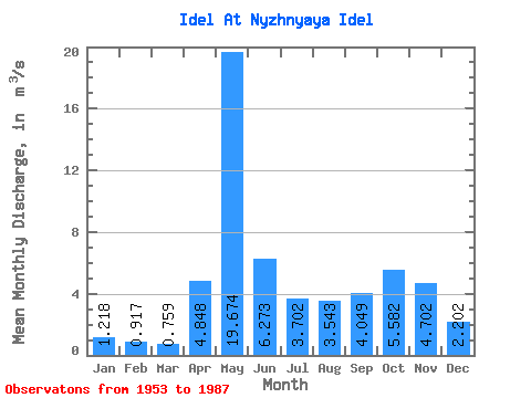
| Statistic | Jan | Feb | Mar | Apr | May | Jun | Jul | Aug | Sep | Oct | Nov | Dec | Annual |
|---|---|---|---|---|---|---|---|---|---|---|---|---|---|
| Mean | 1.22 | 0.92 | 0.76 | 4.85 | 19.67 | 6.27 | 3.70 | 3.54 | 4.05 | 5.58 | 4.70 | 2.20 | 4.74 |
| Standard Deviation | 0.55 | 0.44 | 0.37 | 5.44 | 7.01 | 3.17 | 3.24 | 3.79 | 2.79 | 3.16 | 2.64 | 1.30 | 1.41 |
| Min | 0.47 | 0.38 | 0.30 | 0.50 | 5.57 | 1.71 | 0.54 | 0.69 | 0.82 | 1.25 | 1.16 | 0.55 | 2.71 |
| Max | 2.91 | 2.11 | 1.85 | 21.90 | 34.80 | 15.10 | 16.50 | 15.30 | 9.91 | 14.50 | 10.80 | 6.59 | 9.10 |
| Coefficient of Variation | 0.45 | 0.47 | 0.49 | 1.12 | 0.36 | 0.51 | 0.88 | 1.07 | 0.69 | 0.57 | 0.56 | 0.59 | 0.30 |
 Return to R-Arctic Net Home Page