|
|
|||||||||||||||||
| Point ID: 7315 | Downloads | Plots | Site Data | Code: 49118 |
|
|
|||||||||||||||||
| Download | |
|---|---|
| Site Descriptor Information | Site Time Series Data |
| Link to all available data | |
| View: | Time Series | All |
| Units: | m3/s |
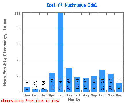
| Statistic | Jan | Feb | Mar | Apr | May | Jun | Jul | Aug | Sep | Oct | Nov | Dec | Annual |
|---|---|---|---|---|---|---|---|---|---|---|---|---|---|
| Mean | 6.15 | 4.22 | 3.83 | 23.71 | 99.41 | 30.68 | 18.70 | 17.90 | 19.80 | 28.20 | 23.00 | 11.12 | 282.36 |
| Standard Deviation | 2.79 | 2.01 | 1.87 | 26.59 | 35.41 | 15.52 | 16.38 | 19.13 | 13.63 | 15.95 | 12.90 | 6.59 | 83.72 |
| Min | 2.38 | 1.75 | 1.52 | 2.44 | 28.14 | 8.36 | 2.73 | 3.49 | 4.01 | 6.32 | 5.67 | 2.78 | 161.22 |
| Max | 14.70 | 9.71 | 9.35 | 107.10 | 175.84 | 73.85 | 83.37 | 77.31 | 48.47 | 73.27 | 52.82 | 33.30 | 542.13 |
| Coefficient of Variation | 0.45 | 0.47 | 0.49 | 1.12 | 0.36 | 0.51 | 0.88 | 1.07 | 0.69 | 0.57 | 0.56 | 0.59 | 0.30 |
 Return to R-Arctic Net Home Page