|
|
|||||||||||||||||
| Point ID: 7303 | Downloads | Plots | Site Data | Code: 49090 |
|
|
|||||||||||||||||
| Download | |
|---|---|
| Site Descriptor Information | Site Time Series Data |
| Link to all available data | |
| View: | Time Series | All |
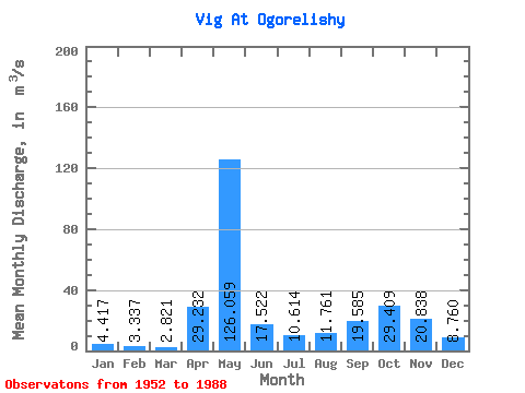
| Units: | mm |
| Statistic | Jan | Feb | Mar | Apr | May | Jun | Jul | Aug | Sep | Oct | Nov | Dec | Annual |
|---|---|---|---|---|---|---|---|---|---|---|---|---|---|
| Mean | 4.42 | 3.34 | 2.82 | 29.23 | 126.06 | 17.52 | 10.61 | 11.76 | 19.59 | 29.41 | 20.84 | 8.76 | 23.70 |
| Standard Deviation | 1.43 | 1.07 | 0.78 | 35.15 | 48.50 | 10.68 | 9.58 | 11.61 | 17.45 | 19.35 | 14.48 | 7.85 | 5.82 |
| Min | 2.15 | 1.76 | 1.62 | 1.97 | 26.10 | 2.25 | 3.27 | 2.50 | 3.06 | 3.37 | 3.38 | 2.98 | 12.11 |
| Max | 8.97 | 7.06 | 5.13 | 149.00 | 219.00 | 65.80 | 58.40 | 55.50 | 92.70 | 104.00 | 66.30 | 47.70 | 35.43 |
| Coefficient of Variation | 0.32 | 0.32 | 0.28 | 1.20 | 0.39 | 0.61 | 0.90 | 0.99 | 0.89 | 0.66 | 0.69 | 0.90 | 0.25 |
 Return to R-Arctic Net Home Page