|
|
|||||||||||||||||
| Point ID: 7303 | Downloads | Plots | Site Data | Code: 49090 |
|
|
|||||||||||||||||
| Download | |
|---|---|
| Site Descriptor Information | Site Time Series Data |
| Link to all available data | |
| View: | Time Series | All |
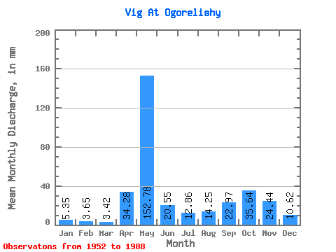
| Units: | m3/s |
| Statistic | Jan | Feb | Mar | Apr | May | Jun | Jul | Aug | Sep | Oct | Nov | Dec | Annual |
|---|---|---|---|---|---|---|---|---|---|---|---|---|---|
| Mean | 5.35 | 3.68 | 3.42 | 34.28 | 152.75 | 20.55 | 12.86 | 14.25 | 22.97 | 35.64 | 24.44 | 10.62 | 338.40 |
| Standard Deviation | 1.73 | 1.18 | 0.94 | 41.23 | 58.77 | 12.53 | 11.61 | 14.07 | 20.47 | 23.45 | 16.98 | 9.52 | 83.15 |
| Min | 2.60 | 1.94 | 1.96 | 2.31 | 31.63 | 2.64 | 3.96 | 3.03 | 3.59 | 4.08 | 3.96 | 3.61 | 172.89 |
| Max | 10.87 | 7.79 | 6.22 | 174.75 | 265.38 | 77.17 | 70.77 | 67.25 | 108.72 | 126.02 | 77.76 | 57.80 | 505.98 |
| Coefficient of Variation | 0.32 | 0.32 | 0.28 | 1.20 | 0.39 | 0.61 | 0.90 | 0.99 | 0.89 | 0.66 | 0.69 | 0.90 | 0.25 |
 Return to R-Arctic Net Home Page