|
|
|||||||||||||||||
| Point ID: 730 | Downloads | Plots | Site Data | Code: 07FD006 |
|
|
|||||||||||||||||
| Download | |
|---|---|
| Site Descriptor Information | Site Time Series Data |
| Link to all available data | |
| View: | Time Series | All |
| Units: | mm |
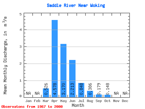
| Statistic | Jan | Feb | Mar | Apr | May | Jun | Jul | Aug | Sep | Oct | Nov | Dec | Annual |
|---|---|---|---|---|---|---|---|---|---|---|---|---|---|
| Mean | 0.53 | 4.58 | 3.17 | 2.21 | 0.85 | 0.39 | 0.18 | 0.15 | |||||
| Standard Deviation | 0.65 | 4.86 | 3.74 | 4.30 | 1.70 | 1.44 | 0.46 | 0.32 | |||||
| Min | 0.00 | 0.09 | 0.03 | 0.03 | 0.00 | 0.00 | 0.00 | 0.00 | |||||
| Max | 2.65 | 19.10 | 16.70 | 22.70 | 8.05 | 8.21 | 2.27 | 1.61 | |||||
| Coefficient of Variation | 1.24 | 1.06 | 1.18 | 1.94 | 2.00 | 3.72 | 2.54 | 2.16 |
 Return to R-Arctic Net Home Page