|
|
|||||||||||||||||
| Point ID: 730 | Downloads | Plots | Site Data | Code: 07FD006 |
|
|
|||||||||||||||||
| Download | |
|---|---|
| Site Descriptor Information | Site Time Series Data |
| Link to all available data | |
| View: | Time Series | All |
| Units: | m3/s |
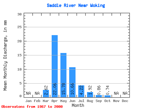
| Statistic | Jan | Feb | Mar | Apr | May | Jun | Jul | Aug | Sep | Oct | Nov | Dec | Annual |
|---|---|---|---|---|---|---|---|---|---|---|---|---|---|
| Mean | 2.62 | 22.06 | 15.78 | 10.66 | 4.22 | 1.92 | 0.86 | 0.73 | |||||
| Standard Deviation | 3.24 | 23.42 | 18.61 | 20.72 | 8.46 | 7.14 | 2.19 | 1.59 | |||||
| Min | 0.00 | 0.41 | 0.14 | 0.13 | 0.01 | 0.00 | 0.00 | 0.00 | |||||
| Max | 13.19 | 92.02 | 83.13 | 109.36 | 40.07 | 40.87 | 10.94 | 8.01 | |||||
| Coefficient of Variation | 1.24 | 1.06 | 1.18 | 1.94 | 2.00 | 3.72 | 2.54 | 2.16 |
 Return to R-Arctic Net Home Page