|
|
|||||||||||||||||
| Point ID: 7288 | Downloads | Plots | Site Data | Code: 49052 |
|
|
|||||||||||||||||
| Download | |
|---|---|
| Site Descriptor Information | Site Time Series Data |
| Link to all available data | |
| View: | Time Series | All |
| Units: | mm |
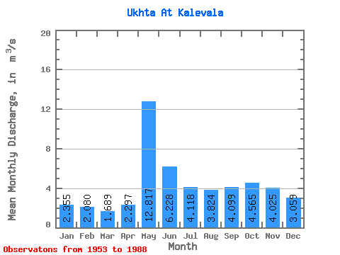
| Statistic | Jan | Feb | Mar | Apr | May | Jun | Jul | Aug | Sep | Oct | Nov | Dec | Annual |
|---|---|---|---|---|---|---|---|---|---|---|---|---|---|
| Mean | 2.35 | 2.08 | 1.69 | 2.30 | 12.82 | 6.23 | 4.12 | 3.82 | 4.10 | 4.56 | 4.03 | 3.06 | 4.26 |
| Standard Deviation | 0.53 | 0.61 | 0.47 | 1.21 | 3.50 | 2.14 | 1.49 | 1.89 | 1.67 | 1.28 | 1.44 | 1.14 | 0.82 |
| Min | 1.34 | 0.82 | 0.43 | 1.06 | 5.32 | 3.26 | 2.19 | 1.57 | 1.01 | 1.95 | 1.69 | 1.41 | 2.31 |
| Max | 3.57 | 3.44 | 2.59 | 6.47 | 21.80 | 12.40 | 7.46 | 8.03 | 8.06 | 7.43 | 7.93 | 7.18 | 5.73 |
| Coefficient of Variation | 0.23 | 0.29 | 0.28 | 0.53 | 0.27 | 0.34 | 0.36 | 0.49 | 0.41 | 0.28 | 0.36 | 0.37 | 0.19 |
 Return to R-Arctic Net Home Page