|
|
|||||||||||||||||
| Point ID: 7288 | Downloads | Plots | Site Data | Code: 49052 |
|
|
|||||||||||||||||
| Download | |
|---|---|
| Site Descriptor Information | Site Time Series Data |
| Link to all available data | |
| View: | Time Series | All |
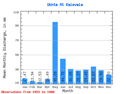
| Units: | m3/s |
| Statistic | Jan | Feb | Mar | Apr | May | Jun | Jul | Aug | Sep | Oct | Nov | Dec | Annual |
|---|---|---|---|---|---|---|---|---|---|---|---|---|---|
| Mean | 17.47 | 14.06 | 12.53 | 16.49 | 95.08 | 44.72 | 30.55 | 28.37 | 29.43 | 33.86 | 28.90 | 22.69 | 372.68 |
| Standard Deviation | 3.95 | 4.12 | 3.45 | 8.68 | 25.96 | 15.39 | 11.03 | 14.01 | 11.99 | 9.49 | 10.32 | 8.44 | 72.13 |
| Min | 9.94 | 5.54 | 3.19 | 7.61 | 39.47 | 23.41 | 16.25 | 11.65 | 7.25 | 14.47 | 12.13 | 10.46 | 202.17 |
| Max | 26.48 | 23.25 | 19.21 | 46.45 | 161.72 | 89.03 | 55.34 | 59.57 | 57.87 | 55.12 | 56.94 | 53.26 | 500.57 |
| Coefficient of Variation | 0.23 | 0.29 | 0.28 | 0.53 | 0.27 | 0.34 | 0.36 | 0.49 | 0.41 | 0.28 | 0.36 | 0.37 | 0.19 |
 Return to R-Arctic Net Home Page