|
|
|||||||||||||||||
| Point ID: 726 | Downloads | Plots | Site Data | Code: 07DD001 |
|
|
|||||||||||||||||
| Download | |
|---|---|
| Site Descriptor Information | Site Time Series Data |
| Link to all available data | |
| View: | Time Series | All |
| Units: | mm |
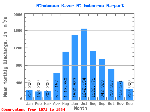
| Statistic | Jan | Feb | Mar | Apr | May | Jun | Jul | Aug | Sep | Oct | Nov | Dec | Annual |
|---|---|---|---|---|---|---|---|---|---|---|---|---|---|
| Mean | 224.20 | 198.20 | 202.20 | 617.17 | 1113.75 | 1500.92 | 1642.15 | 1126.07 | 942.93 | 710.36 | 426.57 | 250.00 | 779.92 |
| Standard Deviation | 47.80 | 39.70 | 19.11 | 235.50 | 379.04 | 416.30 | 456.31 | 162.29 | 345.77 | 199.37 | 84.86 | 53.08 | 31.53 |
| Min | 143.00 | 134.00 | 181.00 | 436.00 | 626.00 | 823.00 | 948.00 | 845.00 | 530.00 | 376.00 | 325.00 | 197.00 | 746.75 |
| Max | 269.00 | 240.00 | 220.00 | 1050.00 | 1970.00 | 2060.00 | 2790.00 | 1360.00 | 1760.00 | 1210.00 | 590.00 | 322.00 | 809.50 |
| Coefficient of Variation | 0.21 | 0.20 | 0.10 | 0.38 | 0.34 | 0.28 | 0.28 | 0.14 | 0.37 | 0.28 | 0.20 | 0.21 | 0.04 |
 Return to R-Arctic Net Home Page