|
|
|||||||||||||||||
| Point ID: 726 | Downloads | Plots | Site Data | Code: 07DD001 |
|
|
|||||||||||||||||
| Download | |
|---|---|
| Site Descriptor Information | Site Time Series Data |
| Link to all available data | |
| View: | Time Series | All |
| Units: | m3/s |
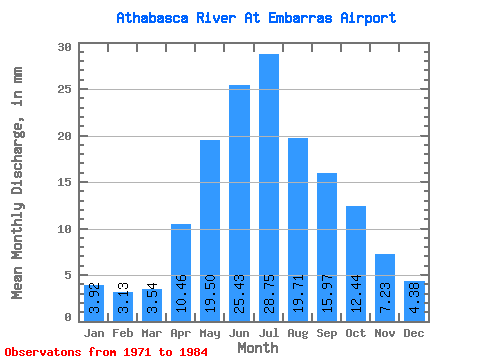
| Statistic | Jan | Feb | Mar | Apr | May | Jun | Jul | Aug | Sep | Oct | Nov | Dec | Annual |
|---|---|---|---|---|---|---|---|---|---|---|---|---|---|
| Mean | 3.87 | 3.12 | 3.49 | 10.32 | 19.24 | 25.10 | 28.37 | 19.46 | 15.77 | 12.27 | 7.13 | 4.32 | 158.80 |
| Standard Deviation | 0.83 | 0.62 | 0.33 | 3.94 | 6.55 | 6.96 | 7.88 | 2.80 | 5.78 | 3.44 | 1.42 | 0.92 | 6.42 |
| Min | 2.47 | 2.11 | 3.13 | 7.29 | 10.82 | 13.76 | 16.38 | 14.60 | 8.86 | 6.50 | 5.43 | 3.40 | 152.05 |
| Max | 4.65 | 3.78 | 3.80 | 17.56 | 34.04 | 34.45 | 48.20 | 23.50 | 29.43 | 20.91 | 9.87 | 5.56 | 164.82 |
| Coefficient of Variation | 0.21 | 0.20 | 0.10 | 0.38 | 0.34 | 0.28 | 0.28 | 0.14 | 0.37 | 0.28 | 0.20 | 0.21 | 0.04 |
 Return to R-Arctic Net Home Page