|
|
|||||||||||||||||
| Point ID: 7248 | Downloads | Plots | Site Data | Code: 12521 |
|
|
|||||||||||||||||
| Download | |
|---|---|
| Site Descriptor Information | Site Time Series Data |
| Link to all available data | |
| View: | Time Series | All |
| Units: | mm |
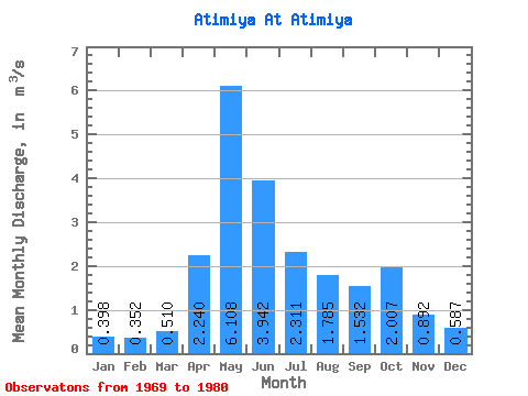
| Statistic | Jan | Feb | Mar | Apr | May | Jun | Jul | Aug | Sep | Oct | Nov | Dec | Annual |
|---|---|---|---|---|---|---|---|---|---|---|---|---|---|
| Mean | 0.40 | 0.35 | 0.51 | 2.24 | 6.11 | 3.94 | 2.31 | 1.79 | 1.53 | 2.01 | 0.89 | 0.59 | 2.15 |
| Standard Deviation | 0.20 | 0.29 | 0.22 | 1.55 | 2.62 | 2.56 | 2.46 | 1.73 | 0.95 | 1.62 | 0.49 | 0.23 | 0.52 |
| Min | 0.10 | 0.02 | 0.15 | 0.59 | 2.00 | 0.84 | 0.63 | 0.54 | 0.54 | 0.54 | 0.50 | 0.19 | 1.82 |
| Max | 0.71 | 0.69 | 0.69 | 5.52 | 9.94 | 8.95 | 8.31 | 6.07 | 3.62 | 5.15 | 2.03 | 0.99 | 2.74 |
| Coefficient of Variation | 0.50 | 0.82 | 0.43 | 0.69 | 0.43 | 0.65 | 1.06 | 0.97 | 0.62 | 0.81 | 0.55 | 0.40 | 0.24 |
 Return to R-Arctic Net Home Page