|
|
|||||||||||||||||
| Point ID: 7248 | Downloads | Plots | Site Data | Code: 12521 |
|
|
|||||||||||||||||
| Download | |
|---|---|
| Site Descriptor Information | Site Time Series Data |
| Link to all available data | |
| View: | Time Series | All |
| Units: | m3/s |
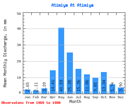
| Statistic | Jan | Feb | Mar | Apr | May | Jun | Jul | Aug | Sep | Oct | Nov | Dec | Annual |
|---|---|---|---|---|---|---|---|---|---|---|---|---|---|
| Mean | 2.65 | 2.13 | 3.39 | 14.41 | 40.59 | 25.36 | 15.36 | 11.86 | 9.86 | 13.34 | 5.74 | 3.90 | 167.96 |
| Standard Deviation | 1.33 | 1.75 | 1.46 | 9.97 | 17.37 | 16.49 | 16.32 | 11.51 | 6.10 | 10.78 | 3.17 | 1.54 | 40.42 |
| Min | 0.67 | 0.10 | 1.00 | 3.79 | 13.29 | 5.40 | 4.19 | 3.59 | 3.47 | 3.59 | 3.22 | 1.26 | 142.59 |
| Max | 4.72 | 4.18 | 4.58 | 35.50 | 66.05 | 57.56 | 55.22 | 40.34 | 23.28 | 34.22 | 13.06 | 6.58 | 214.58 |
| Coefficient of Variation | 0.50 | 0.82 | 0.43 | 0.69 | 0.43 | 0.65 | 1.06 | 0.97 | 0.62 | 0.81 | 0.55 | 0.40 | 0.24 |
 Return to R-Arctic Net Home Page