|
|
|||||||||||||||||
| Point ID: 7244 | Downloads | Plots | Site Data | Code: 12511 |
|
|
|||||||||||||||||
| Download | |
|---|---|
| Site Descriptor Information | Site Time Series Data |
| Link to all available data | |
| View: | Time Series | All |
| Units: | mm |
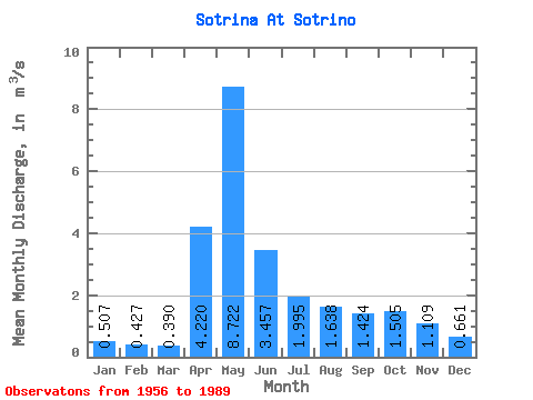
| Statistic | Jan | Feb | Mar | Apr | May | Jun | Jul | Aug | Sep | Oct | Nov | Dec | Annual |
|---|---|---|---|---|---|---|---|---|---|---|---|---|---|
| Mean | 0.51 | 0.43 | 0.39 | 4.22 | 8.72 | 3.46 | 2.00 | 1.64 | 1.42 | 1.50 | 1.11 | 0.66 | 2.14 |
| Standard Deviation | 0.23 | 0.20 | 0.14 | 3.17 | 5.42 | 2.02 | 2.35 | 2.35 | 1.46 | 1.44 | 0.83 | 0.41 | 0.89 |
| Min | 0.26 | 0.09 | 0.10 | 0.47 | 0.77 | 0.63 | 0.27 | 0.30 | 0.22 | 0.21 | 0.25 | 0.12 | 0.86 |
| Max | 1.10 | 0.93 | 0.61 | 13.00 | 23.50 | 8.61 | 10.10 | 12.50 | 6.97 | 6.63 | 3.77 | 2.10 | 4.26 |
| Coefficient of Variation | 0.44 | 0.46 | 0.35 | 0.75 | 0.62 | 0.58 | 1.18 | 1.44 | 1.03 | 0.95 | 0.75 | 0.61 | 0.42 |
 Return to R-Arctic Net Home Page