|
|
|||||||||||||||||
| Point ID: 7244 | Downloads | Plots | Site Data | Code: 12511 |
|
|
|||||||||||||||||
| Download | |
|---|---|
| Site Descriptor Information | Site Time Series Data |
| Link to all available data | |
| View: | Time Series | All |
| Units: | m3/s |
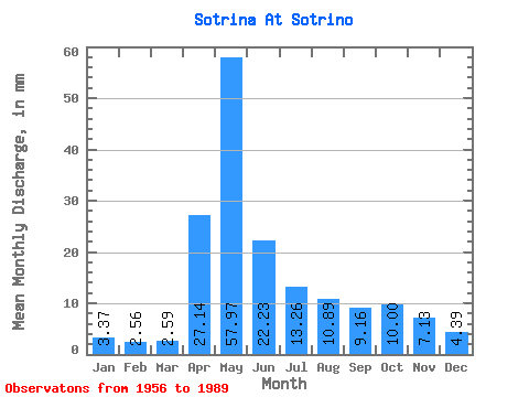
| Statistic | Jan | Feb | Mar | Apr | May | Jun | Jul | Aug | Sep | Oct | Nov | Dec | Annual |
|---|---|---|---|---|---|---|---|---|---|---|---|---|---|
| Mean | 3.37 | 2.58 | 2.59 | 27.14 | 57.96 | 22.23 | 13.25 | 10.88 | 9.16 | 10.00 | 7.13 | 4.39 | 167.91 |
| Standard Deviation | 1.49 | 1.19 | 0.92 | 20.35 | 36.01 | 12.97 | 15.61 | 15.65 | 9.41 | 9.54 | 5.34 | 2.70 | 69.85 |
| Min | 1.73 | 0.56 | 0.66 | 3.02 | 5.12 | 4.05 | 1.79 | 1.99 | 1.42 | 1.40 | 1.61 | 0.80 | 67.74 |
| Max | 7.31 | 5.63 | 4.05 | 83.61 | 156.16 | 55.38 | 67.12 | 83.06 | 44.83 | 44.06 | 24.25 | 13.96 | 333.48 |
| Coefficient of Variation | 0.44 | 0.46 | 0.35 | 0.75 | 0.62 | 0.58 | 1.18 | 1.44 | 1.03 | 0.95 | 0.75 | 0.61 | 0.42 |
 Return to R-Arctic Net Home Page