|
|
|||||||||||||||||
| Point ID: 7243 | Downloads | Plots | Site Data | Code: 12498 |
|
|
|||||||||||||||||
| Download | |
|---|---|
| Site Descriptor Information | Site Time Series Data |
| Link to all available data | |
| View: | Time Series | All |
| Units: | mm |
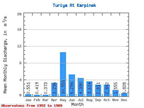
| Statistic | Jan | Feb | Mar | Apr | May | Jun | Jul | Aug | Sep | Oct | Nov | Dec | Annual |
|---|---|---|---|---|---|---|---|---|---|---|---|---|---|
| Mean | 0.55 | 0.42 | 0.37 | 3.30 | 10.55 | 5.29 | 4.39 | 3.61 | 2.81 | 2.84 | 1.56 | 0.83 | 2.98 |
| Standard Deviation | 0.34 | 0.29 | 0.25 | 2.26 | 6.21 | 2.91 | 4.48 | 4.40 | 2.65 | 2.08 | 0.97 | 0.46 | 1.16 |
| Min | 0.00 | 0.01 | 0.02 | 0.37 | 1.39 | 0.75 | 0.44 | 0.74 | 0.58 | 0.90 | 0.50 | 0.20 | 0.96 |
| Max | 1.37 | 1.12 | 0.98 | 9.24 | 27.00 | 12.10 | 27.20 | 23.90 | 10.90 | 9.35 | 4.82 | 1.76 | 5.73 |
| Coefficient of Variation | 0.63 | 0.70 | 0.68 | 0.69 | 0.59 | 0.55 | 1.02 | 1.22 | 0.94 | 0.73 | 0.62 | 0.56 | 0.39 |
 Return to R-Arctic Net Home Page