|
|
|||||||||||||||||
| Point ID: 7243 | Downloads | Plots | Site Data | Code: 12498 |
|
|
|||||||||||||||||
| Download | |
|---|---|
| Site Descriptor Information | Site Time Series Data |
| Link to all available data | |
| View: | Time Series | All |
| Units: | m3/s |
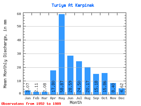
| Statistic | Jan | Feb | Mar | Apr | May | Jun | Jul | Aug | Sep | Oct | Nov | Dec | Annual |
|---|---|---|---|---|---|---|---|---|---|---|---|---|---|
| Mean | 3.08 | 2.13 | 2.08 | 17.80 | 58.87 | 28.59 | 24.49 | 20.16 | 15.18 | 15.85 | 8.40 | 4.62 | 195.99 |
| Standard Deviation | 1.92 | 1.49 | 1.41 | 12.22 | 34.63 | 15.72 | 25.01 | 24.57 | 14.32 | 11.61 | 5.24 | 2.57 | 76.20 |
| Min | 0.01 | 0.05 | 0.10 | 2.00 | 7.75 | 4.05 | 2.46 | 4.13 | 3.13 | 5.02 | 2.70 | 1.12 | 63.32 |
| Max | 7.64 | 5.69 | 5.47 | 49.90 | 150.64 | 65.34 | 151.75 | 133.34 | 58.86 | 52.16 | 26.03 | 9.82 | 376.97 |
| Coefficient of Variation | 0.63 | 0.70 | 0.68 | 0.69 | 0.59 | 0.55 | 1.02 | 1.22 | 0.94 | 0.73 | 0.62 | 0.56 | 0.39 |
 Return to R-Arctic Net Home Page