|
|
|||||||||||||||||
| Point ID: 7236 | Downloads | Plots | Site Data | Code: 12416 |
|
|
|||||||||||||||||
| Download | |
|---|---|
| Site Descriptor Information | Site Time Series Data |
| Link to all available data | |
| View: | Time Series | All |
| Units: | mm |
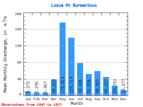
| Statistic | Jan | Feb | Mar | Apr | May | Jun | Jul | Aug | Sep | Oct | Nov | Dec | Annual |
|---|---|---|---|---|---|---|---|---|---|---|---|---|---|
| Mean | 9.37 | 7.29 | 6.97 | 38.63 | 175.82 | 139.72 | 78.44 | 51.84 | 58.93 | 45.03 | 23.31 | 13.38 | 53.97 |
| Standard Deviation | 2.68 | 2.10 | 1.71 | 36.32 | 53.90 | 66.98 | 50.49 | 36.99 | 40.63 | 19.68 | 9.22 | 3.43 | 12.71 |
| Min | 4.75 | 2.61 | 3.95 | 3.83 | 81.60 | 49.80 | 22.40 | 15.60 | 17.90 | 21.70 | 7.25 | 6.70 | 40.03 |
| Max | 14.20 | 10.80 | 10.30 | 154.00 | 326.00 | 306.00 | 247.00 | 196.00 | 211.00 | 90.00 | 43.80 | 19.60 | 97.52 |
| Coefficient of Variation | 0.29 | 0.29 | 0.24 | 0.94 | 0.31 | 0.48 | 0.64 | 0.71 | 0.69 | 0.44 | 0.40 | 0.26 | 0.23 |
 Return to R-Arctic Net Home Page