|
|
|||||||||||||||||
| Point ID: 7236 | Downloads | Plots | Site Data | Code: 12416 |
|
|
|||||||||||||||||
| Download | |
|---|---|
| Site Descriptor Information | Site Time Series Data |
| Link to all available data | |
| View: | Time Series | All |
| Units: | m3/s |
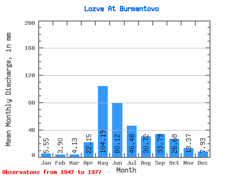
| Statistic | Jan | Feb | Mar | Apr | May | Jun | Jul | Aug | Sep | Oct | Nov | Dec | Annual |
|---|---|---|---|---|---|---|---|---|---|---|---|---|---|
| Mean | 5.55 | 3.94 | 4.13 | 22.15 | 104.17 | 80.12 | 46.47 | 30.71 | 33.79 | 26.68 | 13.37 | 7.92 | 376.84 |
| Standard Deviation | 1.59 | 1.13 | 1.01 | 20.83 | 31.93 | 38.41 | 29.91 | 21.92 | 23.30 | 11.66 | 5.29 | 2.03 | 88.73 |
| Min | 2.81 | 1.41 | 2.34 | 2.20 | 48.35 | 28.56 | 13.27 | 9.24 | 10.27 | 12.86 | 4.16 | 3.97 | 279.51 |
| Max | 8.41 | 5.83 | 6.10 | 88.31 | 193.15 | 175.48 | 146.34 | 116.13 | 121.00 | 53.32 | 25.12 | 11.61 | 680.93 |
| Coefficient of Variation | 0.29 | 0.29 | 0.24 | 0.94 | 0.31 | 0.48 | 0.64 | 0.71 | 0.69 | 0.44 | 0.40 | 0.26 | 0.23 |
 Return to R-Arctic Net Home Page