|
|
|||||||||||||||||
| Point ID: 7229 | Downloads | Plots | Site Data | Code: 12401 |
|
|
|||||||||||||||||
| Download | |
|---|---|
| Site Descriptor Information | Site Time Series Data |
| Link to all available data | |
| View: | Time Series | All |
| Units: | mm |
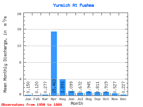
| Statistic | Jan | Feb | Mar | Apr | May | Jun | Jul | Aug | Sep | Oct | Nov | Dec | Annual |
|---|---|---|---|---|---|---|---|---|---|---|---|---|---|
| Mean | 0.15 | 0.12 | 0.28 | 15.46 | 3.89 | 1.10 | 0.67 | 0.94 | 0.81 | 0.92 | 0.53 | 0.23 | 2.08 |
| Standard Deviation | 0.12 | 0.09 | 0.35 | 9.96 | 4.67 | 1.32 | 1.05 | 1.77 | 1.60 | 1.20 | 0.88 | 0.22 | 1.30 |
| Min | 0.01 | 0.00 | 0.01 | 2.05 | 0.50 | 0.03 | 0.03 | 0.02 | 0.02 | 0.02 | 0.06 | 0.03 | 0.48 |
| Max | 0.47 | 0.30 | 1.44 | 38.10 | 22.00 | 6.12 | 5.27 | 8.40 | 7.72 | 4.86 | 5.34 | 1.20 | 6.21 |
| Coefficient of Variation | 0.82 | 0.74 | 1.26 | 0.64 | 1.20 | 1.20 | 1.56 | 1.88 | 1.98 | 1.30 | 1.68 | 0.97 | 0.63 |
 Return to R-Arctic Net Home Page