|
|
|||||||||||||||||
| Point ID: 7229 | Downloads | Plots | Site Data | Code: 12401 |
|
|
|||||||||||||||||
| Download | |
|---|---|
| Site Descriptor Information | Site Time Series Data |
| Link to all available data | |
| View: | Time Series | All |
| Units: | m3/s |
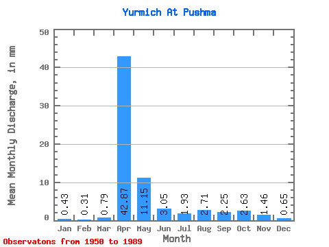
| Statistic | Jan | Feb | Mar | Apr | May | Jun | Jul | Aug | Sep | Oct | Nov | Dec | Annual |
|---|---|---|---|---|---|---|---|---|---|---|---|---|---|
| Mean | 0.43 | 0.31 | 0.79 | 42.87 | 11.15 | 3.05 | 1.93 | 2.71 | 2.25 | 2.63 | 1.46 | 0.65 | 70.18 |
| Standard Deviation | 0.35 | 0.23 | 1.00 | 27.62 | 13.37 | 3.66 | 3.00 | 5.08 | 4.44 | 3.42 | 2.45 | 0.63 | 44.02 |
| Min | 0.01 | 0.01 | 0.03 | 5.68 | 1.43 | 0.07 | 0.07 | 0.06 | 0.06 | 0.07 | 0.17 | 0.07 | 16.31 |
| Max | 1.35 | 0.78 | 4.12 | 105.62 | 63.01 | 16.97 | 15.09 | 24.06 | 21.40 | 13.92 | 14.80 | 3.44 | 209.47 |
| Coefficient of Variation | 0.82 | 0.74 | 1.26 | 0.64 | 1.20 | 1.20 | 1.56 | 1.88 | 1.98 | 1.30 | 1.68 | 0.97 | 0.63 |
 Return to R-Arctic Net Home Page