|
|
|||||||||||||||||
| Point ID: 7225 | Downloads | Plots | Site Data | Code: 12373 |
|
|
|||||||||||||||||
| Download | |
|---|---|
| Site Descriptor Information | Site Time Series Data |
| Link to all available data | |
| View: | Time Series | All |
| Units: | mm |
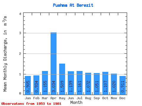
| Statistic | Jan | Feb | Mar | Apr | May | Jun | Jul | Aug | Sep | Oct | Nov | Dec | Annual |
|---|---|---|---|---|---|---|---|---|---|---|---|---|---|
| Mean | 0.91 | 0.93 | 1.16 | 3.03 | 1.51 | 1.14 | 1.16 | 1.07 | 1.05 | 1.11 | 1.02 | 0.91 | 1.23 |
| Standard Deviation | 0.39 | 0.39 | 0.47 | 1.03 | 0.62 | 0.42 | 0.57 | 0.43 | 0.39 | 0.40 | 0.44 | 0.45 | 0.38 |
| Min | 0.22 | 0.26 | 0.26 | 1.44 | 0.61 | 0.39 | 0.26 | 0.28 | 0.42 | 0.41 | 0.21 | 0.10 | 0.54 |
| Max | 1.58 | 1.53 | 2.09 | 5.35 | 3.55 | 1.68 | 2.54 | 1.96 | 1.94 | 1.91 | 1.72 | 1.59 | 1.87 |
| Coefficient of Variation | 0.43 | 0.41 | 0.41 | 0.34 | 0.41 | 0.37 | 0.49 | 0.40 | 0.37 | 0.36 | 0.44 | 0.49 | 0.31 |
 Return to R-Arctic Net Home Page