|
|
|||||||||||||||||
| Point ID: 7225 | Downloads | Plots | Site Data | Code: 12373 |
|
|
|||||||||||||||||
| Download | |
|---|---|
| Site Descriptor Information | Site Time Series Data |
| Link to all available data | |
| View: | Time Series | All |
| Units: | m3/s |
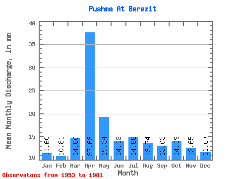
| Statistic | Jan | Feb | Mar | Apr | May | Jun | Jul | Aug | Sep | Oct | Nov | Dec | Annual |
|---|---|---|---|---|---|---|---|---|---|---|---|---|---|
| Mean | 11.60 | 10.90 | 14.80 | 37.63 | 19.34 | 14.12 | 14.87 | 13.73 | 13.03 | 14.18 | 12.64 | 11.67 | 186.53 |
| Standard Deviation | 5.05 | 4.52 | 6.04 | 12.81 | 7.91 | 5.27 | 7.27 | 5.47 | 4.88 | 5.13 | 5.51 | 5.72 | 57.90 |
| Min | 2.82 | 3.04 | 3.33 | 17.86 | 7.82 | 4.84 | 3.33 | 3.59 | 5.21 | 5.25 | 2.60 | 1.22 | 81.73 |
| Max | 20.25 | 17.86 | 26.78 | 66.35 | 45.49 | 20.84 | 32.55 | 25.11 | 24.06 | 24.47 | 21.33 | 20.37 | 282.63 |
| Coefficient of Variation | 0.43 | 0.41 | 0.41 | 0.34 | 0.41 | 0.37 | 0.49 | 0.40 | 0.37 | 0.36 | 0.44 | 0.49 | 0.31 |
 Return to R-Arctic Net Home Page