|
|
|||||||||||||||||
| Point ID: 7218 | Downloads | Plots | Site Data | Code: 12309 |
|
|
|||||||||||||||||
| Download | |
|---|---|
| Site Descriptor Information | Site Time Series Data |
| Link to all available data | |
| View: | Time Series | All |
| Units: | mm |
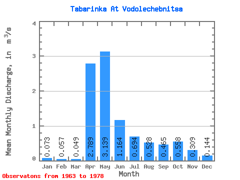
| Statistic | Jan | Feb | Mar | Apr | May | Jun | Jul | Aug | Sep | Oct | Nov | Dec | Annual |
|---|---|---|---|---|---|---|---|---|---|---|---|---|---|
| Mean | 0.07 | 0.06 | 0.05 | 2.79 | 3.14 | 1.16 | 0.69 | 0.53 | 0.47 | 0.56 | 0.31 | 0.14 | 0.88 |
| Standard Deviation | 0.05 | 0.05 | 0.04 | 2.10 | 2.65 | 0.75 | 1.02 | 0.54 | 0.39 | 0.51 | 0.29 | 0.11 | 0.46 |
| Min | 0.01 | 0.00 | 0.01 | 0.60 | 0.45 | 0.18 | 0.14 | 0.08 | 0.10 | 0.14 | 0.08 | 0.03 | 0.28 |
| Max | 0.19 | 0.17 | 0.16 | 7.31 | 10.20 | 2.65 | 4.30 | 1.68 | 1.42 | 1.90 | 1.20 | 0.41 | 1.79 |
| Coefficient of Variation | 0.72 | 0.82 | 0.85 | 0.75 | 0.84 | 0.65 | 1.47 | 1.02 | 0.84 | 0.91 | 0.94 | 0.76 | 0.52 |
 Return to R-Arctic Net Home Page