|
|
|||||||||||||||||
| Point ID: 7218 | Downloads | Plots | Site Data | Code: 12309 |
|
|
|||||||||||||||||
| Download | |
|---|---|
| Site Descriptor Information | Site Time Series Data |
| Link to all available data | |
| View: | Time Series | All |
| Units: | m3/s |
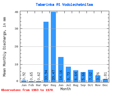
| Statistic | Jan | Feb | Mar | Apr | May | Jun | Jul | Aug | Sep | Oct | Nov | Dec | Annual |
|---|---|---|---|---|---|---|---|---|---|---|---|---|---|
| Mean | 0.92 | 0.65 | 0.62 | 33.94 | 39.47 | 14.17 | 8.73 | 6.64 | 5.66 | 7.02 | 3.75 | 1.81 | 130.30 |
| Standard Deviation | 0.67 | 0.54 | 0.52 | 25.50 | 33.29 | 9.18 | 12.86 | 6.80 | 4.73 | 6.39 | 3.52 | 1.37 | 67.55 |
| Min | 0.16 | 0.02 | 0.13 | 7.30 | 5.66 | 2.19 | 1.76 | 0.97 | 1.18 | 1.76 | 0.95 | 0.31 | 40.93 |
| Max | 2.39 | 1.95 | 2.01 | 88.95 | 128.24 | 32.25 | 54.06 | 21.12 | 17.28 | 23.89 | 14.60 | 5.16 | 264.98 |
| Coefficient of Variation | 0.72 | 0.82 | 0.85 | 0.75 | 0.84 | 0.65 | 1.47 | 1.02 | 0.84 | 0.91 | 0.94 | 0.76 | 0.52 |
 Return to R-Arctic Net Home Page