|
|
|||||||||||||||||
| Point ID: 7204 | Downloads | Plots | Site Data | Code: 12217 |
|
|
|||||||||||||||||
| Download | |
|---|---|
| Site Descriptor Information | Site Time Series Data |
| Link to all available data | |
| View: | Time Series | All |
| Units: | mm |
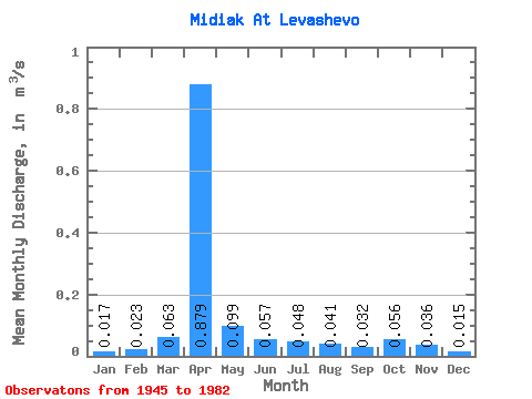
| Statistic | Jan | Feb | Mar | Apr | May | Jun | Jul | Aug | Sep | Oct | Nov | Dec | Annual |
|---|---|---|---|---|---|---|---|---|---|---|---|---|---|
| Mean | 0.02 | 0.02 | 0.06 | 0.88 | 0.10 | 0.06 | 0.05 | 0.04 | 0.03 | 0.06 | 0.04 | 0.01 | 0.17 |
| Standard Deviation | 0.03 | 0.05 | 0.11 | 0.99 | 0.09 | 0.06 | 0.06 | 0.05 | 0.04 | 0.09 | 0.05 | 0.01 | 0.15 |
| Min | 0.00 | 0.00 | 0.00 | 0.03 | 0.01 | 0.01 | 0.00 | 0.00 | 0.00 | 0.01 | 0.00 | 0.00 | 0.02 |
| Max | 0.15 | 0.20 | 0.49 | 4.93 | 0.35 | 0.36 | 0.27 | 0.23 | 0.18 | 0.43 | 0.26 | 0.04 | 0.58 |
| Coefficient of Variation | 1.91 | 2.00 | 1.67 | 1.13 | 0.90 | 1.11 | 1.27 | 1.27 | 1.13 | 1.65 | 1.47 | 0.67 | 0.87 |
 Return to R-Arctic Net Home Page