|
|
|||||||||||||||||
| Point ID: 7204 | Downloads | Plots | Site Data | Code: 12217 |
|
|
|||||||||||||||||
| Download | |
|---|---|
| Site Descriptor Information | Site Time Series Data |
| Link to all available data | |
| View: | Time Series | All |
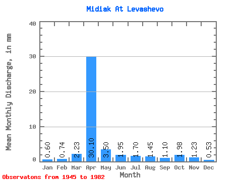
| Units: | m3/s |
| Statistic | Jan | Feb | Mar | Apr | May | Jun | Jul | Aug | Sep | Oct | Nov | Dec | Annual |
|---|---|---|---|---|---|---|---|---|---|---|---|---|---|
| Mean | 0.59 | 0.74 | 2.24 | 30.08 | 3.51 | 1.95 | 1.70 | 1.47 | 1.10 | 1.99 | 1.24 | 0.55 | 72.83 |
| Standard Deviation | 1.13 | 1.48 | 3.74 | 34.08 | 3.15 | 2.17 | 2.15 | 1.87 | 1.25 | 3.28 | 1.82 | 0.37 | 63.22 |
| Min | 0.04 | 0.03 | 0.07 | 1.16 | 0.28 | 0.24 | 0.14 | 0.07 | 0.10 | 0.18 | 0.03 | 0.11 | 9.94 |
| Max | 5.31 | 6.45 | 17.33 | 168.81 | 12.38 | 12.33 | 9.55 | 8.14 | 6.16 | 15.21 | 8.90 | 1.49 | 241.81 |
| Coefficient of Variation | 1.91 | 2.00 | 1.67 | 1.13 | 0.90 | 1.11 | 1.27 | 1.27 | 1.13 | 1.65 | 1.47 | 0.67 | 0.87 |
 Return to R-Arctic Net Home Page